Since Plumas Lake is an unincorporated community, there is no official boundary. Even if we were incorporated, adjacent areas would likely still be considered PL, much like adjacent areas to Wheatland are still Wheatland, even if they are outside the city limits. The fact that we share a ZIP code makes the question even more complicated as we can’t look to the ZIP to help define what (and where) is Plumas Lake.
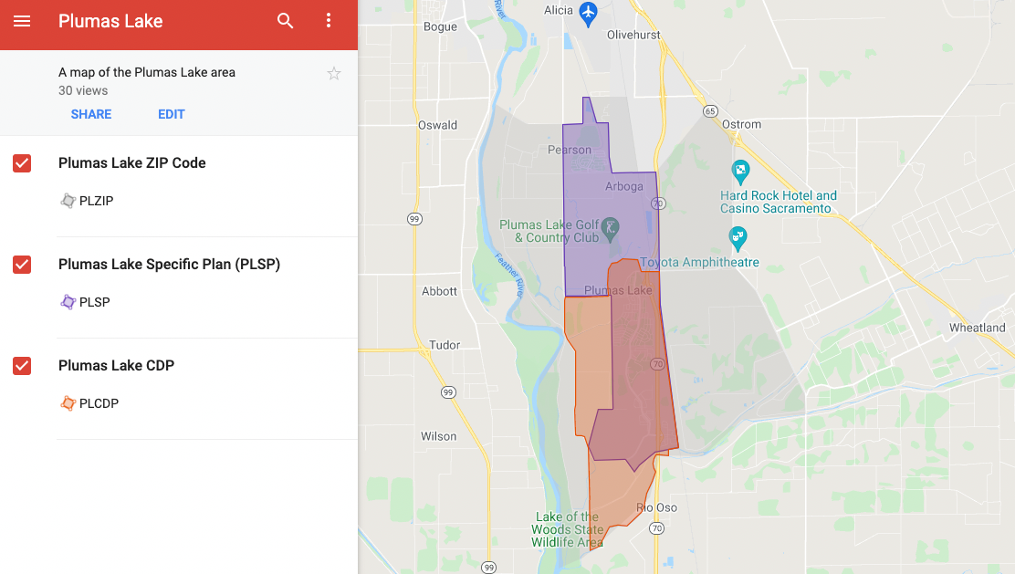
Plumas Lake CDP
The smallest of the three is the Plumas Lake Census Designated Place (CDP). The Plumas Lake CDP is essentially south Plumas Lake (the area south of Algodon Rd) and adjacent rural areas. This is the area that the census uses to count the population of Plumas Lake.
Plumas Lake Specific Plan
Others might use the Plumas Lake Specific Plan (PLSP) to define what is Plumas Lake and what isn’t. This is all of south Plumas Lake, Wheeler Ranch, and the areas in between, like the golf course. Eventually, River Oaks will connect to Arboga Rd and development will occur in between, making it feel more like a single community and less like “north PL” and “south PL”.
Plumas Lake ZIP Code Area
This essentially includes the Plumas Lake Specific Plan area, new developments along Arboga Rd, and adjacent areas to the east and west within the existing 95961 ZIP code. It essentially breaks the 95961 ZIP code into two sections with the northern section remaining Olivehurst (and West Linda) and the southern section being Plumas Lake (and Arboga).
I put together a few layers on Google Maps that you can use to view these areas, either individually, or all together. I hope it’s helpful.
Note: The google map layers are a rough representation of the PL CDP, PLSP, and PL ZIP boundaries and shouldn’t be used to determine if a specific point near the border is in or out of a specific layer.